

Land Ecosystem Atmosphere Program (LEAP) - Wombat OzFlux Flux Tower Site

Investigators and Partners
This project is the product of the combined efforts of many interdisciplinary researchers of various expertise and is currently operated by:
- Prof Stefan Arndt (Ecophysiologist)(UniMelb)
- Prof Jason Beringer (Micrometeorology)(UWA)
- Dr Stephen Livesely (Ecologist)(UniMelb)
Project Overview
The Wombat State Forest Flux Tower site, not only monitors ecosystem fluxes of energy, water and carbon dioxide above-ground, with a flux tower, but also below-ground. The below-ground measurements are obtained using an automated chamber system that is connected to a Fourier Transformed Infrared Spectrometer in a mobile laboratory on site.
Experimental plots with rainfall reduction treatments will be used to study the effect of rainfall reduction and drought on the carbon and greenhouse gas cycles. These experimental approaches will allow a better understanding of the processes that control the carbon and greenhouse gas balance in the dry eucalypt forest systems in Australia. Thus, researchers will be able to make a thorough assessment of how changes in our climate will influence the carbon exchange processes in forests, and the vulnerabilities of these forests with regard to their carbon balance. In the long run the Wombat Flux site will also enable study of the impact of forest disturbances on the carbon and greenhouse gas balance.
The site provides nationally consistent observations of vegetation dynamics, faunal biodiversity, micrometeorology (climate, radiation, fluxes of carbon and water), hydrology and biogeochemistry to examine the impacts of fire regime, climate on carbon stocks and GHG emissions, and impacts on habitat quality via ongoing monitoring of vegetation structure and fauna. A wide range of ground based observations of vegetation structure and floristics is planned and all will link to remote sensing of fire and vegetation change over time. Measurements of carbon sequestration through time will be achieved via the instrumentation capable of directly measuring CO2, water use and surface energy properties (energy balance, reflectance).
The Wombat site is one of two nodes on the Victorian Dry Eucalypt SuperSite that is actually a regional SuperSite hub consisting of several nodes including Whroo and Riggs Creek sites. This new regional SuperSite’s vision is to provide the scientific infrastructure and institutional collaboration required for world-class science and sustainable management of terrestrial ecosystems in South Eastern Australia based on a sound understanding of their structure, composition, functions and processes.
The tower will provide longterm measurements as part of the Ozflux network and the infrastructure is partly funded through the NCRIS TERN.
Key research questions
The Wombat Forest research site facilitates the investigation of complex ecosystem processes of the carbon, water and nutrient cycle in a dry-sclerophyll forest ecosystem that is typical for many forests in Australia. This research will help to assess the impact of future environmental change on forest ecosystems in Australia. The Wombat Forest research site will:
The Site Location
The Wombat Flux research site was established in January 2010. The site is located within the Wombat State Forest, between Ballarat and Daylesford in Central Victoria, 100km west of Melbourne. Ths site is located at: Latitude: -37.4222 S Longitude: 144.0944 E
Site Characteristics
The Wombat Forest research site is located in the Wombat State Forest, Victoria, South Eastern Australia at an elevation of 713m.
The site is a secondary re-growth forest that was last harvested in 1980. Dominant tree species are Eucalyptus obliqua (messmate stringybark), Eucalyptus radiata (narrow leaf peppermint) and Eucalyptus rubida (candlebark) with an average canopy height of 25m.
The understorey consists mainly of patchy grasses and the soil is a silty-clay overlying clay. The forest is managed by the Department of Sustainability and Environment and management includes selective harvesting and prescribed burning regimes.
The climate of the study area is classified as cool-temperate to Mediterranean zone with cold and wet winters (May-Aug) and warm and dry summers (Dec-Feb). Mean annual rainfall in the region in the last 20 years was between 600-700 mm.
Data
Data from this site is available through the OzFlux data portal international FLUXNET database or via the investigators email jason.beringer[@]uwa.edu.au
Further Information
- Prof. Jason Beringer homepage
- School of Earth and Environment
- The Australian Flux Network (OzFlux)
- The Terrestrial Ecosystem Science Network (TERN)
- The Terrestrial Ecosystem Science Network (TERN) Supersite network
- The National Collaborative Research Infrastructure Strategy (NCRIS)
- The International FLUXNET
Acknowledgements
This site is produced by Prof. Jason Beringer, UWA, School of Earth and Environment and proudly part of the Australian Flux Network(OzFlux) and partly supported by the Australian NCRIS Terrestrial Ecosystem Research Network (TERN).

The Wombat Flux research site consists of a main flux tower site and three satellite sites.
The main flux tower site includes the following instrumentation that is located in a secured and locked compound:
-
35 m tall eddy-covariance flux tower;
-
trailer-mounted mobile laboratory – Fourier transform infra-red (FTIR) spectrometer, including automated sampling chambers;
-
remote area power system (diesel generator and 12V battery bank)
The EC flux tower at the main flux tower site continuously measures the exchange of CO2, water vapour and energy between the atmosphere and the forest through equipment mounted on the tower. This main tower site also includes a full weather station.
The FTIR in the trailer-mounted mobile laboratory continuously measures the flux of greenhouse gases (CO2, CH4 and N2O) between the soil and atmosphere that are collected during the closure of automated chambers.
The three satellite sites are located within a 1km radius from the tower and include control plots (no treatment) and rainfall reduction plots (40% rainfall reduction) to study the effect of drought on ecosystem processes. Moreover soil respiration processes are investigated by partitioning soil respiration in its component fluxes heterotrophic and autotrophic respiration. Greenhouse gas fluxes (CO2, CH4) are measured using manual chamber techniques coupled with a greenhouse gas analyser (FGGA).
Instrumentation of the Eddy Covariance tower
| Instrument Type | Make | Model | Situation |
|---|---|---|---|
| IRGA Open path - density CO2, H2O - atmospheric pressure |
LI-COR | LI-7500 | 30m |
| 3D sonic anemometer - wind velocities (u,v,w) - sonic temperature |
Campbell | CSAT-3 | 30m |
| Air temperature, Humidity - T, Rh |
Vaisalla | HMP-45C | 2, 5, 10, 20, 30m |
| PAR Radiation - PPFD - PPFD diffuse |
AT | Sunshine - BF3 | 30m |
| Pyrgeometer Radiation - Longwave radiation in and out (Lin Lout) | Kipp and Zonen | CG2 | 30m |
| Pyranometer Shortwave radiation (Kin, Kout, albedo) | Kipp and Zonen | CM 7B | 30m |
| Net Radiation - Rn |
Kipp and Zonen | NRLite | 30m |
| Rainfall - Rain |
Hydrological services | CS702 | 30m |
| Wind direction, speed - W dir , W vel |
RM Young | Wind sentry | 30m |
| Soil temperature | Thermocouple | -0.1, 0.2, 0.4, 0.8, 1.5m 5m from tower | |
| Soil temperature (averaging array) |
Campbell | TCAV | Surface to 10cm avg 5m from tower |
| Soil heat flux plates | Campbell | HFT3 | -0.1m 5m from tower |
| Soil water content (time domain reflectometer type probe) |
Campbell | CS616 | 0.1, 0.2, 0.4, 0.8, 1.5m 5m from tower |
| Automatic weather station - temperature - Relative Humidity |
1.5m, situated 1.5 and | ||
| Data Loggers | Campbell | CR-3000 CR-10X |
5m |
| Communications | Campbell NL115 ethernet and CF card adaptor and Maxon Ethernet modem | ||
| Power Supply - 12V DC EC flux station |
Kyocera - solar panels (4) (BP) |
120W ea | 60-80m |
Instrumentation of the FTIR
| Instrument Type | Make | Model | Situation |
|---|---|---|---|
| FTIR spectrometer | Bruker Optik; IR cube with thermo-electrically cooled MCT detector | Matrix-M | Field laboratory |
| Thermostatically controlled housing | University of Wollongong | Field laboratory | |
| White cell fixed path (26 m) sample cell (4 L) | IR analysis, Anaheim, CA | 24PA | Field laboratory |
| 4 stage diaphragm vacuum pump | Vaccu Brand, Germany | MV2 | Field laboratory |
| Gas manifold (controls valve swith, flow, pressure, drying) | University of Wollongong | Field laboratory | |
| Carrier gas | Linde | Ultra-high purity | Field laboratory |
| Standard calibration gas | CSIRO | CO2, CO, H2O, N2O, CH4, 13CO2, 2H | Field laboratory |
| Tower profile manifold (controls valve switch, purge) | University of Wollongong | Field laboratory | |
| 2 stage diaphragm pump | Thomas | Field laboratory | |
| Control lap-top (Oscar, Opus, DCON-Utility software) | Dell | Field laboratory | |
| Chamber manifold (controls valve switch, TDR, soil temp.) | University of Wollongong | Field laboratory | |
| Automated pneumatic chambers | Chinese Academy of Science | Festo pneumatic pistons | Tower base (0m) |
| Soil moisture probes | Delta T, UK | Theta ML2X | Tower base (0m) |
| Soil temperature probes | Univ. Wollongong | Tower base (0m) | |
| 4.5 kW Diesel generator (Yanmar) and 12V battery bank | Watts 2C, QLD | Powermaker Ranger 4.5 | Tower base (0m) |
| 1.5 hP Air compressor | Pilot | K8 | Tower base (0m) |
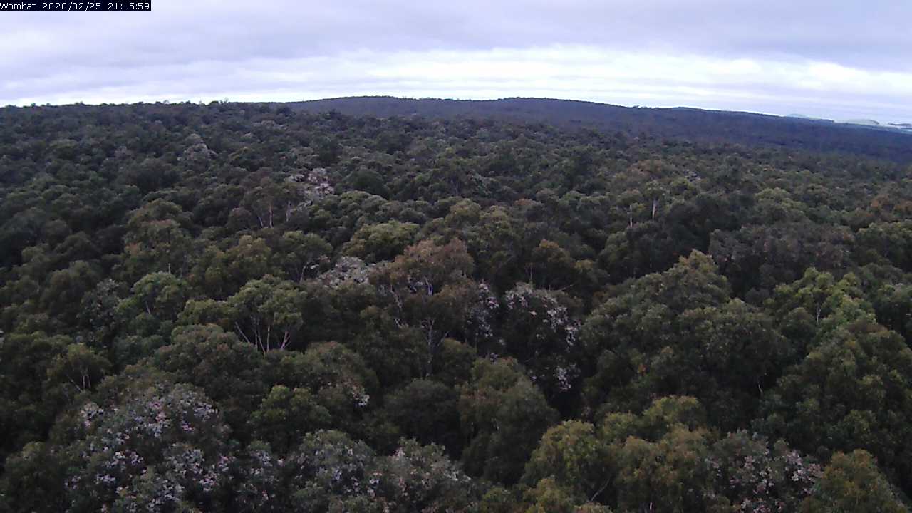
This image is taken by a Vivotek Network Camera (IP8362) and is updated every 30 minutes. The timestamp is provided in Coordinated Universal Time (UTC).
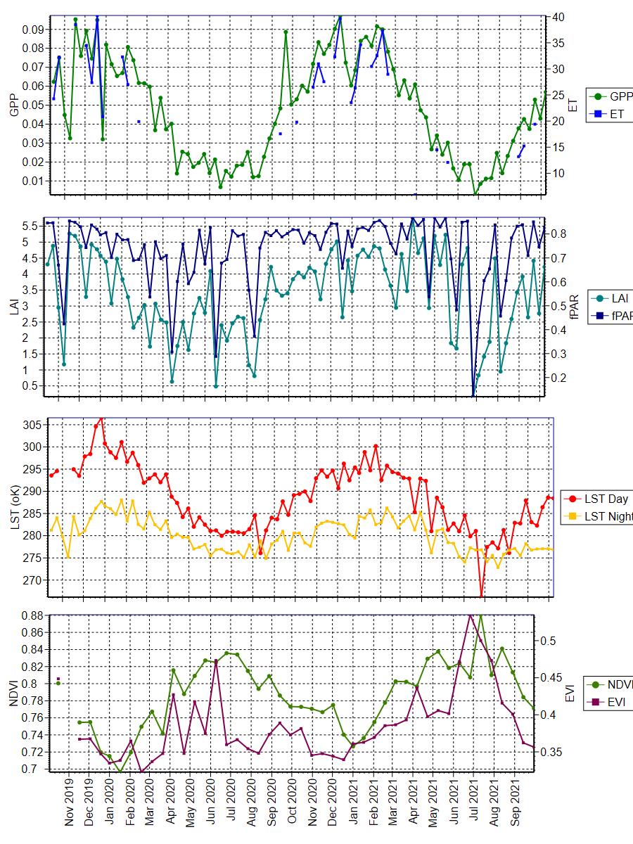
The data was obtained from the Oak Ridge National Laboratory Distributed Active Archive Center for Biogeochemical Dynamics (ORNL DAAC) (https://daac.ornl.gov/MODIS/). The ORNL DAAC provides MODIS Land Product Subsets for model validation, site characterisation and remote-sensing purposes.
Daily updated data was obtained from this provider, with an area of 3x3km extracted using Python script written by Mr. Darien Pardinas-Diaz ([email protected]). The plots were produced using QC Filter Conditions 000 and 001. Condition 000 represents the highest QC Filter possible and 001 represents a reliable and usable QC Filter, though not to the standard of 000.

University information
CRICOS Code: 00126G