

Land Ecosystem Atmosphere Program (LEAP) - Great Western Woodland (GWW) OzFlux Flux Tower Site

Investigators and Partners
This Terrestrial Ecosystem Research Network (TERN) research site is facilitated by the Department of Parks and Wildlife WA, and supported by a range of researchers. The site is operated by:
- Dr Craig Macfarlane (CSIRO Land and Water)
- Dr Suzanne Prober (CSIRO Land and Water)
- Georg Wiehl (CSIRO Land and Water)
Project Overview
The Great Western Woodlands comprise a 16 million hectare mosaic of temperate woodland, heathland and mallee vegetation in semi-arid south-western Australia. The region is extraordinary in that it has remained largely intact since European settlement, owing to the variable rainfall and lack of readily accessible groundwater. The woodland vegetation of the region is globally unique: no other area supports woodland vegetation at as low as 260 mm mean annual rainfall. Further, other temperate woodlands in Australia and around the world have typically become highly fragmented and degraded through agricultural use.
The Great Western Woodlands thus provide a unique model for studying how naturally functioning, intact ecosystems can adapt to climate change, and for understanding how woodland ecosystems in highly variable climates function at site and landscape scales. As part of the Terrestrial Ecosystem Research Network (TERN) Ozflux Network and TERN Supersite Network, an intensive research site has been established at Credo near Coolgardie. This includes a flux tower and on-ground monitoring that deliver nationally consistent data streams on vegetation dynamics, faunal biodiversity, micrometeorology (climate, radiation, fluxes of carbon and water), hydrology and biogeochemistry; to examine the impacts of climate on carbon stocks, greenhouse gas emissions, biodiversity and ecosystem processes. Research at Credo links with a range of related projects across a wider area of the GWW SuperSite (e.g. the Gimlet Fire Chronosequence led by Dr Carl Gosper).
Infrastructure is funded through the NCRIS TERN.
Key research questions
Current and emerging research questions at the GWW OzFlux and SuperSite include:
- What are the impacts of climate change and management on the fundamental flows of energy, carbon, water and nutrient stocks in semi-arid woodland ecosystems?
- Are old-growth semi-arid woodlands carbon sources or carbon sinks?
- Are fire regimes changing in the GWW?
- How do GWW biodiversity and fire fuels change with time since fire and what are the implications for fire management?
- How do GWW woodlands and shrublands persist at low rainfall? What are the ecological determinants of the Menzies line (the striking boundary between the GWW and mulga) and how does it inform management for climate adaptation?
- How will biodiversity be affected by climate change? Will the response of fauna depend predominantly depend on vegetation responses?
- How will regional versus population-scale genetic variability in key traits such as water use efficiency contribute to climate adaptation?
- What are the thresholds of woodland persistence with respect to fire and rainfall?
- What exotic species are invading the GWW, and which are the greatest threat under climate change?
- How did Indigenous Australians manage GWW ecosystems?
The Site Location
The GWW flux station is located on the Credo Proposed Conservation Reserve approximately 90 km NW of Coolgardie, Western Australia. It was established in December 2012 and is managed by CSIRO Land and Water, facilitated by a steering committee including members from Department of Parks and Wildlife WA, University of Western Australia, Edith Cowan University and TERN.
Site Characteristics
The flux tower site is located within an area of magnificent old-growth eucalypt woodland to 20 m tall, including Salmon gum (Eucalyptus salmonophloia), Gimlet (E. salubris) and Redwood (E. transcontinentalis). The shrub understorey is dominated by Maireana, Atriplex, Eremophila and Acacia spp. This is the characteristic vegetation of broad valley floors with deep clay soils in region. The surrounding areas on Credo include other woodlands, chenopod shrublands, mallee, mulga and sandplain shrublands.
Elevation of the site is close to 450 m, mean annual rainfall is approximately 260 mm, and mean annual temperature at Credo is 19°C
Data
Data from this site is available through the TERN OzFlux data portal and the international FLUXNET database, the TERN SuperSite data portal, and via the investigators: email craig.macfarlane[@]csiro.au, or [email protected].
Further Information
- The Australian Flux Network (OzFlux)
- Critical Zone Exploration Network
- The Terrestrial Ecosystem Science Network (TERN)
- The Terrestrial Ecosystem Science Network (TERN) Supersite network
- The National Collaborative Research Infrastructure Strategy (NCRIS)
- The International FLUXNET
Acknowledgements
This site is produced by Prof. Jason Beringer, UWA, School of Earth and Environment and proudly part of the Australian Flux Network(OzFlux) and partly supported by the Australian NCRIS Terrestrial Ecosystem Research Network (TERN).
Instrument |
Make |
Model |
Description |
Atmospheric Pressure |
Licor |
LI7500A |
36m |
Net Radiation |
Kipp and Zonen |
CNR4 |
36m |
Net Radiation |
Kipp and Zonen |
NR Lite |
36m |
Data logger |
Campbell Scientific |
CR3000 |
Ground |
Open Path CO2 H2O |
LI-COR |
Li-7500 |
36m |
Rain gauge |
Rimco |
RIM8000 |
Ground |
Soil heat flux (three replicates) |
Hukseflux |
HFP01 |
0.08m |
Soil temperature (averaging array) |
Campbell Scientific |
TCAV-L |
0.08m |
Sonic anemometer |
Campbell Scientific |
CSAT3 |
36m |
Temperature and Relative Humidity (two replicates) |
Vaisala |
HMP155 |
3m |
Temperature and Relative Humidity (two replicates) |
Vaisala |
HMP155 |
36m |
Soil Moisture west (8 replicates) |
Campbell Scientific |
CS616 |
0.05, 0.1, 0.2, 0.3 (2), 0.5, 0.7, 1.1-1.4 m |
Soil Moisture east (8 replicates) |
Campbell Scientific |
CS616 |
0.05, 0.1, 0.2, 0.3 (2), 0.5, 0.7, 1.1-1.4 m |
Soil temperature (5 replicates) |
Campbell Scientific |
CS107 |
0.05, 0.1, 0.2, 0.3, 0.5 m |
2D Wind speed/direction |
Windsonic |
4L |
36m |
Communications |
Maxon |
Modmax 6280IND |
Ground |
Multiplexer |
Campbell Scientific |
AM16/32B |
Ground |
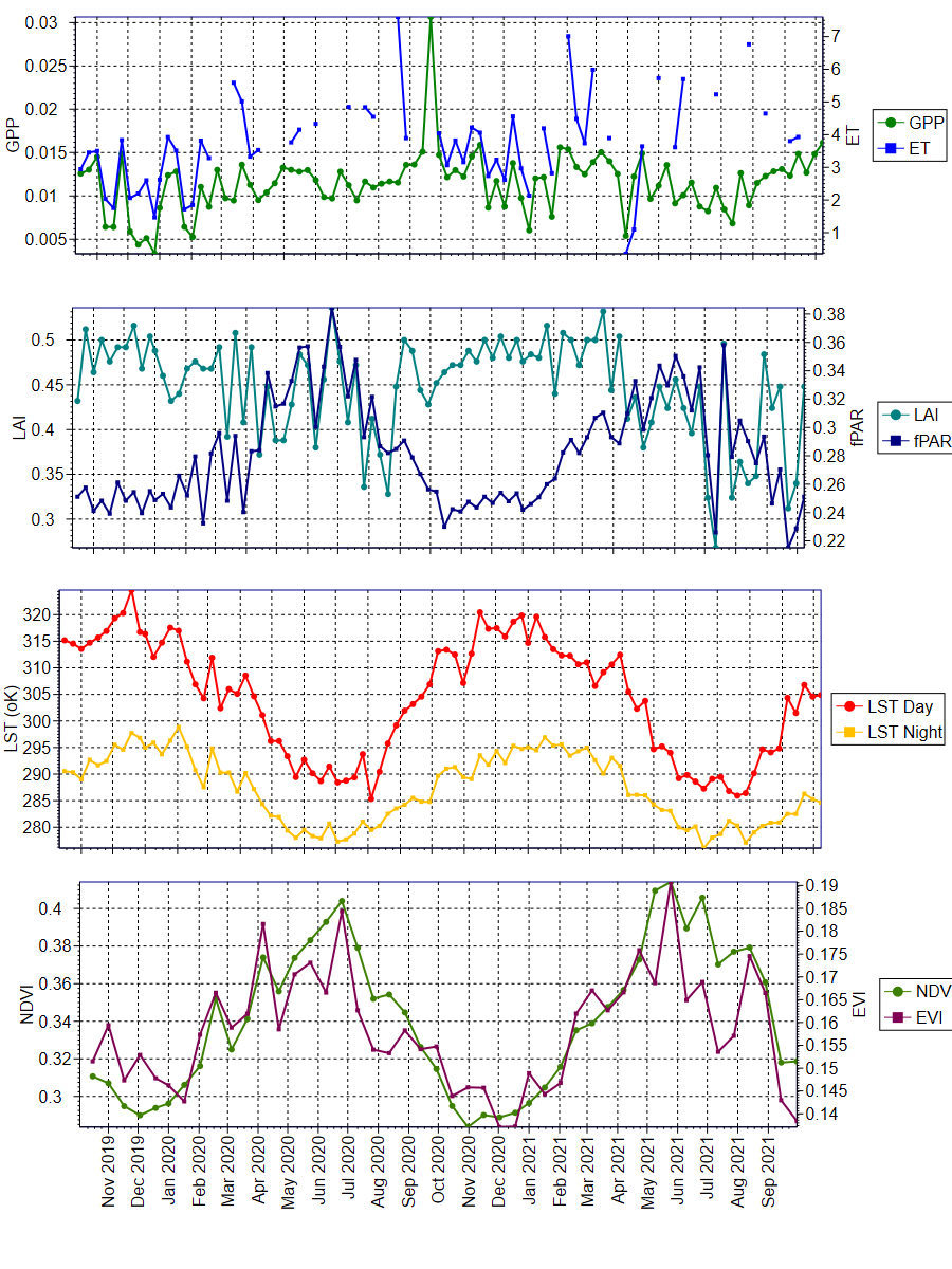
The data was obtained from the Oak Ridge National Laboratory Distributed Active Archive Center for Biogeochemical Dynamics (ORNL DAAC) (https://daac.ornl.gov/MODIS/). The ORNL DAAC provides MODIS Land Product Subsets for model validation, site characterisation and remote-sensing purposes.
Daily updated data was obtained from this provider, with an area of 3x3km extracted using Python script written by Mr. Darien Pardinas-Diaz ([email protected]). The plots were produced using QC Filter Conditions 000 and 001. Condition 000 represents the highest QC Filter possible and 001 represents a reliable and usable QC Filter, though not to the standard of 000.
University information
CRICOS Code: 00126G