

Land Ecosystem Atmosphere Program (LEAP) - Yanco Flux Tower Site

Investigators and Partners
This project is the product of the combined efforts of many interdisciplinary researchers of various expertise and the investigators involved in this project are:
The contributors involved in this project are:
Project Overview
Its purpose is to obtain data for validation of GCOM-W1 soil moisture products, which are components of a land surface data assimilation system. These data systems are important for land surface models, which rely on atmosphere-surface observations. Information provided by an existing network of soil moisture monitoring systems will also be used to validate the GCOM-W1 soil moisture product. The tower will provide longterm measurements as part of the Ozflux network .
Key research aims
The Site Location
The flux tower monitoring system is located within the Yanco region of New South Wales, Australia (Latitude: -34.99 S Longitude: 146.29 E). The Yanco area of the flux tower site is located in the western plains of the Murrumbidgee Catchment and is within a wider research area (60 x 60 km) that supports a network of OzNet stations, which have been in operation since late 2001 onwards.
Site Characteristics
The Yanco area of the flux tower site is located in the western plains of the Murrumbidgee Catchment. This is a topographically flat area, primarily comprised of the following soil types: sandy loams, scattered clays, red brown earths, transitional red brown earth, sands over clay and deep sands. Stream valleys and layered soil and sedimentary materials are found across the landscape.
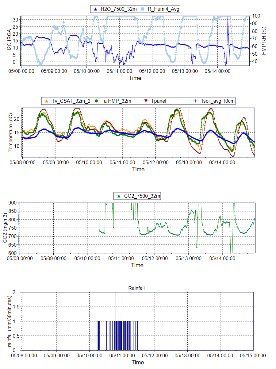
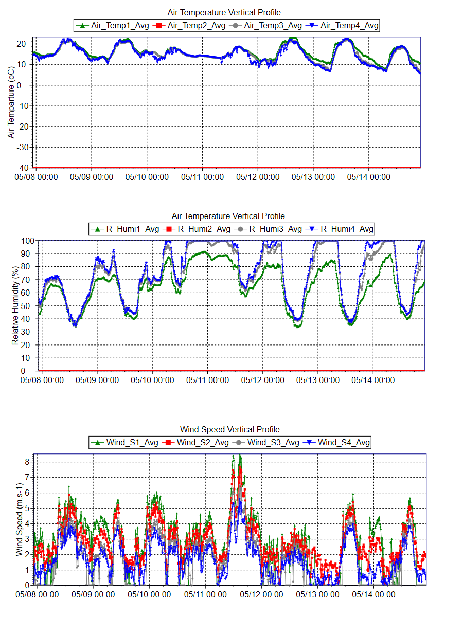
The tower on site extends to 20m, however flux measurements are recorded from slightly lower than this (see measurements table for more details). Mean annual precipitation from a nearby Bureau of Meteorology site measured 465 mm. Maximum temperatures ranged from 37.4ºC (in January) to 16.6ºC (in July), while minimum temperatures ranged from 29.0ºC (in January) to 11.8ºC (in July). Maximum temperatures varied on a seasonal basis by approximately 20.8ºC and minimum temperatures by 17.2ºC.
Data
Data from this site is available through the OzFlux data portal international FLUXNET database or via the investigators email jason.beringer[@]uwa.edu.au
Further Information
- Prof. Jason Beringer homepage
- Prof. Jeffrey Walker homepage
- Dr. Christoph Rudiger homepage
- Dr. Edoardo Daly homepage
- School of Earth and Environment
- Monash University
- The Japan Aerospace Exploration Agency (JAXA)
- The Australian Flux Network (OzFlux)
- The Terrestrial Ecosystem Science Network (TERN)
- The Terrestrial Ecosystem Science Network (TERN) Supersite network
- The National Collaborative Research Infrastructure Strategy (NCRIS)
- The International FLUXNET
Acknowledgements
This project is supported by the Japan Aerospace Exploration Agency, in collaboration with Monash University, Australia. This site is produced by Prof. Jason Beringer, UWA, School of Earth and Environment and proudly part of the Australian Flux Network(OzFlux).


Tower equipment
Instrument |
Model |
Ultra sonic anemometer |
CSAT3-CC-ST |
H20/CO2 analyzer |
LI-7500A, LI-7500 |
Wind sensor |
034B |
Temperature and humidity probe with ventilation unit |
HMP115, PCV-04 |
Radiation frame equipment
Instrument |
Model |
Pyranometer with defrosting fan |
CMP21, PO-03 |
Pyrgeometer with defrosting fan |
CGR4, PO-03 |
PAR quantum sensor |
PQS1 |
Infrared radiation thermometer |
SI-111 |
Ground surface equipment
Instrument |
Model |
Rain gauge |
TKF-1-UD |
Barometer |
PTB210 |
System equipment
Instrument |
Model |
Data logger |
CR1000-4M, AM16, NL115 |
Power switch box |
Power Control Box |
Transformer DC12V-DV24V |
DC24V Power |
DC power supply |
EX-375L2 |
Sub-weather observation system
Instrument |
Model |
Automatic station for soil hydrology components |
ASSH-T |
System main unit |
CR1000-4M, C-PS100 |
Solar panel |
C-MSX10 |
Multi-weather sensor |
Weather transmitter, WTX520 |
Soil temperature sensor |
C-HPT |
Soil moisture sensor |
TRIME-PICO32 |
Soil heat flux sensor |
HF-HFP01 |
Infrared radiation thermometer |
SI-111 |
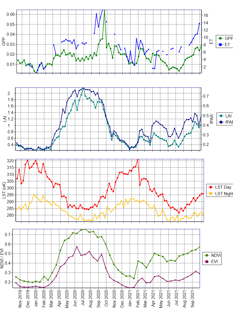
The data was obtained from the Oak Ridge National Laboratory Distributed Active Archive Center for Biogeochemical Dynamics (ORNL DAAC) (https://daac.ornl.gov/MODIS/). The ORNL DAAC provides MODIS Land Product Subsets for model validation, site characterisation and remote-sensing purposes.
Daily updated data was obtained from this provider, with an area of 3x3km extracted using Python script written by Mr. Darien Pardinas-Diaz ([email protected]). The plots were produced using QC Filter Conditions 000 and 001. Condition 000 represents the highest QC Filter possible and 001 represents a reliable and usable QC Filter, though not to the standard of 000.

University information
CRICOS Code: 00126G